
(This is the second in a two-part series on a very short history of Dutch Flanders/Zeeuws Vlaanderen and my family’s relation to it. You can catch the first part here.)
An apology is in order, and I owe it to my great-grands. So here it is: I’m sorry I thought the lot of them were a bunch of boring clayhoppers.
It’s not that they were Dutch, or even that they were Zeelanders. It’s that I assumed they came such inconsequential places and led sleepy lives. Not a one of them claimed a home address in Amsterdam, much less Leiden, den Haag, Delft, Utrecht or Haarlem. I only found one or two who had any connection to Middelberg, the swinging capital of Zeeland during the Golden Age.
To a one of them, all of my ancestors were rural. And aside from an occasional shopkeeper or carpenter, they all seemed to be farmers. Which isn’t anything unusual, of course. For the vast sweep of human history, the majority of humanity was involved in the production of food in one way or another: farming, fishing, herding. Most of our great-grands were peasants or terms similar — tenant farmer, serfs, landman, whatever. It just didn’t make for interesting research.
Or so I thought. But I’d forgotten to take the context of history into account.
Building a borderland
I want to focus for now on just one part of the old family tree — the part that came from a curious part of the Netherlands known as Zeeuws Vlaanderen, or Dutch Flanders. It’s the southwesternmost part of the Netherlands, but not connected to the rest of the country by land at all. Instead, it borders Belgium.
Zeelanders pulled land from the sea.
And that’s really the essence of Zeeuws Vlaanderen. It’s a land between: between Belgium and the Netherlands; between the forces of the Calvinist Dutch and Catholic Spain; between Polish liberation forces and the nazi occupiers. Heck, between the land and sea itself. Zeeuws Vlaanderen has forever been on the frontlines.
But for a long time, Zeeuws Vlaanderen just … wasn’t.
Here, take a look at what I mean (click the map of Netherlands if the video doesn’t automatically play). You need to understand that Zeeuws Vlaanderen wasn’t some place ready-made that people stumbled into and settled down in. Oh, no no no. As the saying goes, God created the world, but the Dutch created Holland. But more specifically, the Zeelanders pulled their land from the sea. It’s literally their motto: I struggle and emerge, the words on the Zeeland coat of arms, shows a lion rising from the sea. When children are born in Zeeland, it’s not said that they are brought by a stork or found in a cabbage patch — they are “pulled from the clay.”
Zeeland grew as those enterprising Zeelanders used windmills, dikes and canals to move water where they wanted it and keep it away from where they didn’t. Pretty amazing, isn’t it?
As land was created, it built up a delta for the Scheldt river. And that river was to become massively important historically. Follow the Scheldt out to sea and curve to the south a bit and you reach Bruges, which was THE spot to see and sell everything from wool to wine back in the 1300s and 1400s. It lies no further than seven miles from Zeeuws Vlaanderen, and its place in the mercantile world went unrivaled until its harbor started to silt up around 1500, and trade shifted north to Antwerp.
Antwerp, lying on the banks of the Scheldt, overtook Bruges as the trading capital of Europe in the 1500s and became the wealthiest city north of the Alps. Like Bruges, it was close cousins with Zeeuws Vlaanderen, being as close as five miles from the Dutch border
One other thing? All that wealth and ease of transport was about to draw a lot of attention to this little part of the world.
Our history of troubles
Between Bruges and Antwerp lay an inlet known as Sluis harbor (then spelled Sluys). It was, in fact, a roadstead, which is a naval term for a large natural harbor where ships can safely anchor without fear of snagging. Places like these were often used strategically as places for fleets to gather, either in preparation for a journey or to prepare for a battle.
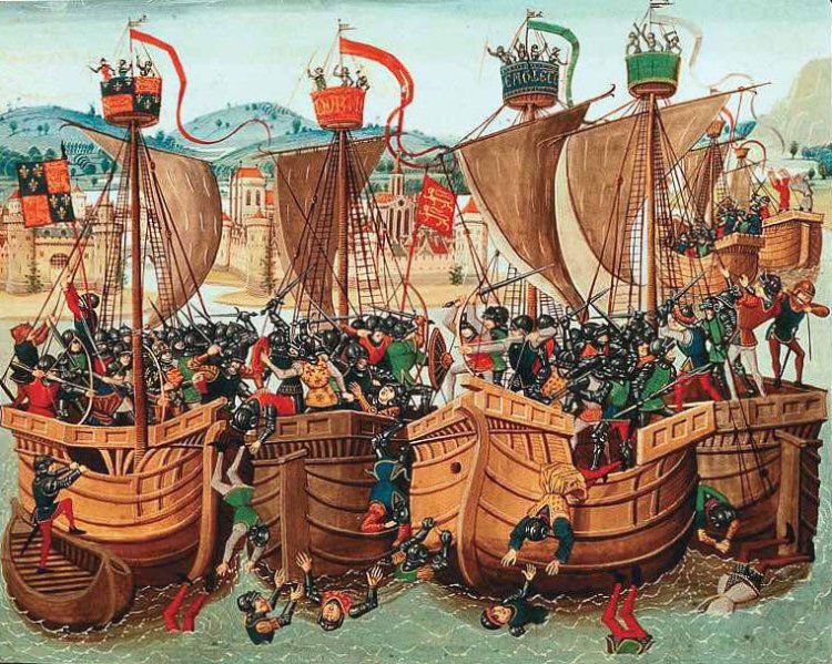
In June 1340, it was a battle that was on the horizon. It was, in fact, one of the first major battles in the Hundred Years War.
On June 24, the English found the French fleet holed up in Sluis harbor. The French tried to arrange their fleet into three strategic lines and tie them together into a floating platform, but the winds were against them and caused their ships to become entangled. They were now literally sitting ducks, and the English took full advantage. When all was said and done, as many as 20,000 French forces were slaughtered. It was said that bodies continued to wash up on the Flemish shore for days after, and that it was the largest number of casualties the French suffered in any battle up to the modern era of warfare.
Most of the French who died did so by drowning. The few who made it to shore were killed by local Flemish population, who apparently sympathized with the English. Those people? Those were my ancestors. This was their backyard.
The decisive English win effectively meant that England would not be invaded by the French, and that the majority of the Hundred Year’s War would be fought in France. Except, of course, when it strayed into Flanders.
